

The next named tropical storm in the Atlantic Basin will be Humberto.
The next named tropical storm in the Atlantic Basin will be Humberto, and we could have that within the next 24 hours.
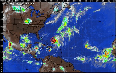
The low pressure area will be moving to the west-northwest over the next few days. Interests in the Cape Verde Islands should keep abreast of the potential for heavy rain and gusty winds by Monday.
Gabrielle, a tropical rainstorm, is a couple of hundred miles northeast of the southeastern Bahamas. The leftover low-level circulation remains broad and poorly defined. The system will continue to track to the north on Sunday and then track northward or northeastward early next week ahead of a cold front.
Westerly winds aloft should inhibit any development or organization through Sunday, but there may be a period of more conducive conditions for organization early next week. As it stands, even if there were to be a regeneration of Gabrielle, there is no threat to land.

Another area to watch in the coming days will continue to be down in the southwestern Gulf of Mexico and Bay of Campeche. Pressures are low, moisture is high and waters are warm, so it is not out of the question that any surface trough or mid- or upper-level feature gets some shower and thunderstorm activity going that will start the process of tropical development. Just something to keep an eye on for now as we head into and through the new week.
Keine Kommentare:
Kommentar veröffentlichen
Hinweis: Nur ein Mitglied dieses Blogs kann Kommentare posten.