

Montag, 29. Oktober 2012
Hurricane Sandy kurz vor Landfall
Hurricane Sandy wird in der kommenden Nacht auf Land treffen.

Sandy continues to maintain an area of deep convection near the
center...with an eye occasionally visible on satellite imagery.
Although the satellite presentation of the system is not very
impressive...SFMR measurements...flight-level winds...and dropsonde
data from the Air Force hurricane hunters indicate that the winds
have increased to near 75 kt.  Since the hurricane will traverse
the Gulf Stream this morning...and the shear is not too strong at
this time...some more strengthening as a tropical cyclone is
possible in the next few hours.  However...the main mechanism
for intensification later today should be baroclinic forcing.  The
official wind speed forecast is close to the latest GFS prediction
as that model should be able to handle the evolution of this type
of system fairly well.

Surface data indicate that a well-marked warm and cold front lie not far to the north and west of the center of Sandy. As the circulation interacts with these fronts...the cyclone should become extratropical later today. Extratropical transition is expected to be complete before the center crosses the coast. However...this transformation will not diminish the overall impacts from winds to hurricane strength...life-threatening storm surge...and flooding rains associated with this dangerous weather system. Based on the global models...the cyclone should weaken fairly rapidly after landfall.Center fixes indicate that Sandy is now moving northward or about 360/13...as it begins to rotate around a mid- to upper-level cyclone over the southeastern United States. As it moves between the cyclone and a highly anomalous mid-tropospheric ridge near Atlantic Canada...Sandy should turn northwestward and west-northwestward with some further increase in forward speed. This track should result in the center making landfall in the mid-Atlantic states this evening or tonight. After landfall...the dynamical guidance shows a significant slowing of forward speed as the system merges with the mid- to upper-level cyclone. Sandy now moving north-northwestward and accelerating... ...Expected to bring life-threatening storm surge and coastal hurricane winds plus heavy appalachian snows...location...36.8n 71.1w about 265 mi...425 km se of Atlantic City New Jersey about 310 mi...505 km SSE of New York City maximum sustained winds...85 mph...140 km/h present movement...NNW or 330 degrees at 20 mph...32 km/h minimum central pressure...946 mb...27.94 inchesat 800 am EDT...1200 UTC...the center of Hurricane Sandy was located near latitude 36.8 north...longitude 71.1 west. Sandy is now moving toward the north-northwest near 20 mph...32 km/h. A turn toward the northwest is expected later this morning...followed by a turn toward the west-northwest tonight. On the forecast track...the center of Sandy will move over the coast of the mid-Atlantic states this evening or tonight.Reports from an Air Force hurricane hunter aircraft indicate that the maximum sustained winds remain near 85 mph...140 km/h...with higher gusts. Sandy is expected to transition into a frontal or wintertime low pressure system prior to landfall. However...this transition will not be accompanied by a weakening of the system... and in fact...a little strengthening is possible during this process. Sandy is expected to weaken after moving inland.Hurricane-force winds extend outward up to 175 miles...280 km...from the center...and tropical-storm-force winds extend outward up to 485 miles...780 km. Sustained tropical-storm-force winds are occurring along the coasts of southern New Jersey...Delaware...and eastern Virginia...and extend as far inland as the central and southern Chesapeake Bay.The minimum central pressure estimated from hurricane hunter aircraft data is 946 mb...27.94 inches.

Freitag, 26. Oktober 2012


Dienstag, 23. Oktober 2012
Tropensturm Sandy formt sich vor Jamaica.
Tropischer Sturm Sandy.
Der tropische Sturm Sandy mit Windgeschwindigkeiten von 40 mph, bis zu 50 mph in den Spitzen, verhält sich fast stationär in der südwestlichen Karibik.
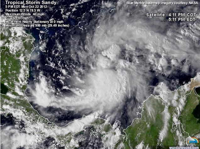
Innerhalb der kommenden 24 Stunden soll Sandy an Geschwindigkeit und Stärke zunehmen, eventuell sehr rasch könnte sich der Sturm zum Hurrikan entwickeln. Begünstigt wird dies durch die sehr warmen Wassertemperaturen von 29,5 Grad C.
Voraussichtlich am Mittwochnachmittag wird Sandy über Jamaica ziehen und am Donnerstagmorgen auf Kuba treffen und im weiteren Verlauf über die Bahamas fegen.

Environmental conditions . . .

consisting of low shear...warm waters...
and a moist atmosphere...favor strengthening during the next
couple of days.  In fact...all of the intensity models bring
Sandy to hurricane strength within 36 to 48 hours and so does
the NHC forecast.  After Sandy crosses eastern Cuba...the
vertical shear is forecast to increase significantly...however the
global models depict a deepening cyclone...possibly due to some
baroclinic forcing.  The NHC forecast still indicates the system
becoming subtropical late in the period...although there are some
indications in the global models that Sandy could be transitioning
to an extratropical cyclone around that time.

Forecast positions and Max windsinit 23/0900z 13.3n 78.6w 40 kt 45 mph 12h 23/1800z 14.1n 78.2w 50 kt 60 mph 24h 24/0600z 15.6n 77.8w 60 kt 70 mph 36h 24/1800z 17.6n 77.4w 70 kt 80 mph 48h 25/0600z 19.6n 77.0w 70 kt 80 mph 72h 26/0600z 24.0n 76.0w 60 kt 70 mph 96h 27/0600z 26.8n 74.8w 60 kt 70 mph 120h 28/0600z 30.0n 71.5w 60 kt 70 mph...subtropical
Abonnieren
Posts (Atom)