

Tropischer Sturm Sandy.
Der tropische Sturm Sandy mit Windgeschwindigkeiten von 40 mph, bis zu 50 mph in den Spitzen, verhält sich fast stationär in der südwestlichen Karibik.
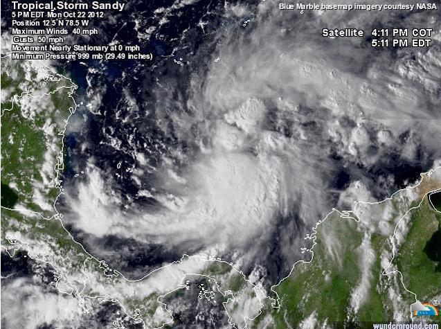
Innerhalb der kommenden 24 Stunden soll Sandy an Geschwindigkeit und Stärke zunehmen, eventuell sehr rasch könnte sich der Sturm zum Hurrikan entwickeln. Begünstigt wird dies durch die sehr warmen Wassertemperaturen von 29,5 Grad C.
Voraussichtlich am Mittwochnachmittag wird Sandy über Jamaica ziehen und am Donnerstagmorgen auf Kuba treffen und im weiteren Verlauf über die Bahamas fegen.

Environmental conditions . . .

consisting of low shear...warm waters...
and a moist atmosphere...favor strengthening during the next
couple of days.  In fact...all of the intensity models bring
Sandy to hurricane strength within 36 to 48 hours and so does
the NHC forecast.  After Sandy crosses eastern Cuba...the
vertical shear is forecast to increase significantly...however the
global models depict a deepening cyclone...possibly due to some
baroclinic forcing.  The NHC forecast still indicates the system
becoming subtropical late in the period...although there are some
indications in the global models that Sandy could be transitioning
to an extratropical cyclone around that time.

Forecast positions and Max windsinit 23/0900z 13.3n 78.6w 40 kt 45 mph 12h 23/1800z 14.1n 78.2w 50 kt 60 mph 24h 24/0600z 15.6n 77.8w 60 kt 70 mph 36h 24/1800z 17.6n 77.4w 70 kt 80 mph 48h 25/0600z 19.6n 77.0w 70 kt 80 mph 72h 26/0600z 24.0n 76.0w 60 kt 70 mph 96h 27/0600z 26.8n 74.8w 60 kt 70 mph 120h 28/0600z 30.0n 71.5w 60 kt 70 mph...subtropical
Keine Kommentare:
Kommentar veröffentlichen
Hinweis: Nur ein Mitglied dieses Blogs kann Kommentare posten.