Mittwoch, 31. Juli 2013

Massive African Dust Storm

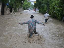
Massive African Dust Storm Cooling Atlantic Hurricane Odds for Early August.


 A massive dust storm that formed over the Sahara Desert early this week has now pushed out over the tropical Atlantic, and will sharply reduce the odds of tropical storm formation during the first week of August. The dust is accompanied by a large amount of dry air, which is making the Saharan Air Layer (SAL) much drier than usual this week. June and July are the peak months for dust storms in the Southwest Sahara, and this week's dust storm is a typical one for this time of year. Due in large part to all the dry and dusty air predicted to dominate the tropical Atlantic over the next seven days, none of the reliable computer models is predicting Atlantic tropical cyclone formation during the first week of August.


 How dust affects hurricanes
Saharan dust can affect hurricane activity in several ways:

1) Dust acts as a shield which keeps sunlight from reaching the surface. Thus, large amounts of dust can keep the sea surface temperatures up to 1°C cooler than average in the hurricane Main Development Region (MDR) from the coast of Africa to the Caribbean, providing hurricanes with less energy to form and grow. Ocean temperatures in the MDR are currently 0.7°F above average, and this anomaly should cool this week as the dust blocks sunlight.

2) The Saharan Air Layer (SAL) is a layer of dry, dusty Saharan air that rides up over the low-level moist air over the tropical Atlantic. At the boundary between the SAL and low-level moist air where the trade winds blow is the trade wind inversion--a region of the atmosphere where the temperature increases with height. Since atmospheric temperature normally decreases with height, this "inversion" acts to but the brakes on any thunderstorms that try to punch through it. This happens because the air in a thunderstorm's updraft suddenly encounters a region where the updraft air is cooler and less buoyant than the surrounding air, and thus will not be able to keep moving upward. The dust in the SAL absorbs solar radiation, which heats the air in the trade wind inversion. This makes the inversion stronger, which inhibits the thunderstorms that power a hurricane.

3) Dust may also act to produce more clouds, but this effect needs much more study. If the dust particles are of the right size to serve as "condensation nuclei"--centers around which raindrops can form and grow--the dust can act to make more clouds. Thus, dust could potentially aid in the formation and intensification of hurricanes. However, if the dust acts to make more low-level clouds over the tropical Atlantic, this will reduce the amount of sunlight reaching the ocean, cooling the sea surface temperatures and discouraging hurricane formation (Kaufman et al., 2005.)


 Dust in Africa's Sahel region and Atlantic hurricane activity
 
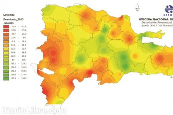
The summertime dust that affects Atlantic tropical storms originates over the southwestern Sahara (18° - 22° N) and the northwestern Sahel (15° - 18° N) (Figure 3.) The dust from the Southwest Sahara stays relatively constant from year to year, but the dust from the Northwest Sahel varies significantly, so understanding this variation may be a key factor in improving our forecasts of seasonal hurricane activity in the Atlantic. The amount of dust that gets transported over the Atlantic depends on a mix of three main factors: the large scale and local scale weather patterns (windy weather transports more dust), how wet the current rainy season is (wet weather will wash out dust before it gets transported over the Atlantic), and how dry and drought-damaged the soil is. The level of drought experienced in the northwestern Sahel during the previous year is the key factor of the three in determining how much dust gets transported over the Atlantic during hurricane season, according to a January 2004 study published in Geophysical Research Letters published by C. Moulin and I. Chiapello. In 2012 (Figure 3), precipitation across the northwestern Sahel was much above average, which should result in less dust than usual over the Atlantic this fall, increasing the odds of a busy 2013 hurricane season.


Links
 
Saharan Air Layer Analysis from the University of Wisconsin

Atlantic dust forecast from the Tel-Aviv University Weather Research Center

Dr. Amato Evan published a study in Science magazine March 2009 showing that 69% of the increase in Atlantic sea surface temperatures over the past 26 years could be attributed to decreases in the amount of dust in the atmosphere.

Kaufman, Y. J., I. Koren, L. A. Remer, D. Rosenfeld, and Y. Rudich, 2005a: The effect of smoke, dust, and pollution aerosol on shallow cloud development over the Atlantic Ocean. Proc. Natl. Acad. Sci. USA, 102, 11 207–11 212.

Wang, Chunzai, Shenfu Dong, Amato T. Evan, Gregory R. Foltz, Sang-Ki Lee, 2012, Multidecadal Covariability of North Atlantic Sea Surface Temperature, African Dust, Sahel Rainfall, and Atlantic Hurricanes, J. Climate, 25, 5404–5415.
doi: http://dx.doi.org/10.1175/JCLI-D-11-00413.1

Mittwoch, 24. Juli 2013

Tropical Storm Dorian

Dorian Forms in the Tropical Atlantic


Tropical Storm Dorian has formed late this morning in the eastern Atlantic. Recent satellite imagery shows a well organized cluster of thunderstorms around the center of circulation and a well-defined outflow in the upper levels of the atmosphere.


Although this has developed into an organized tropical system, it will have to fight adverse environmental conditions as it heads westward across the Atlantic. A large area of dry, dusty air sits to the west of this system which will help to inhibit thunderstorm development over the next few days. Dorian will traverse cooler waters and experience an increase in wind shear, which will both help to limit further intensification into the latter part of the week.


Computer forecasts take this feature west-northwest to near the Leeward Islands on Saturday night and Sunday. Due to the factors discussed above, it is quite possible that by the time this system reaches the Leeward Islands, it will have intensified very little and will still be a weak tropical storm.
The rest of the Atlantic is relatively quiet with a weak tropical wave along 75 west. This wave is not expected to develop over the next few days.


Donnerstag, 11. Juli 2013

Turismo y música en un solo evento

La oferta incluye a Gilberto Santa Rosa, Frank Reyes, Eddy Herrera, Yiyo Sarante, David Kada, Tueska y otros. 


Luego de un colorido show artístico protagonizado por el Ballet Folklórico del Ministerio de Turismo dieron por hecho la celebración del Latin Music Tours 2013  a realizarse los días 15, 16, 17 y 18 del próximo mes de agosto en el Hard Rock Hotel y Casino Punta Cana.

El anuncio fue hecho durante una rueda de prensa efectuada en el salón La Mancha del Hotel Barceló Santo Domingo, a la que asistieron parte de los cantantes protagonistas del encuentro musical, donde además el productor artístico del evento, Juan Carlos Jiménez, y la empresa organizadora Quepe Tours, dieron a conocer los detalles del encuentro que supone “será la mejor entrega del Latin Music’’.

En el encuentro se confirmaron los nombres de los artistas: Yiyo Sarante y David Kada, quienes además estarán debutando por primera vez, al igual que la cantante colombiana Tueska, así como los merengueros Eddy Herrera y Miriam Cruz.


La lista incluye la participación de los jóvenes talentos Brashell y Janko Santos; los dembowseros Carlitos Way y CrazyDesing (Los Teke Teke)  y la actuación del bachatero Frank Reyes; así como también el Ángel Dorado y los Dj Crisk, Carlos y Tribil.

En el plano internacional tendrán participación el dúo puertorriqueño de reggaetón Rakim y Ken-y y el caballero de la salsa, Gilberto Santa Rosa. El súper bonche comienza el jueves 15 con una fiesta de blanco en la playa a cargo de David Kada y la participación especial de los jóvenes Brashell y Janko Santos.
El viernes, el show continuará en el salón Fillmore del Hard Rock Hotel y Casino Punta Cana, con las actuaciones del bachatero Frank Reyes, la merenguera Miriam Cruz y desde la isla del encanto el caballero de la salsa, Gilberto Santa Rosa.


Al día siguiente, sábado 17, será el “pool party’’ y el  “bikini bash’’, desde las 3:00 de la tarde, en una de las 15 piscinas del complejo hotelero con la presentación de Los Teke Teke y el dúo Ángel Dorado.
Esa misma noche en el salón Fillmore subirán a escena  Tueska, Yiyo Sarante, el dueto puertorriqueño  Rakim y Ken-Y y Eddy Herrera.

Yubelkis Ramírez, gerente de marca de Brahma Light, principal patrocinador del evento, explicó que se realizarán concursos en las diversas redes sociales de la compañía a  fin de llevar a los consumidores a disfrutar de la experiencia.
Los ganadores serán transportados en avión privado a Punta Cana y luego trasladados en limosina hasta el Hard Rock Hotel y Casino, adelantó Ramírez al destacar las novedades de la promoción.


LO QUE VIENE

Los paquetes turísticos


Complejo.
El director de Quepe Tours, Fernando Quezada (en la imagen arriba), habló sobre los diferentes paquetes turísticos para el público. El empresario dijo que el evento servirá para hacer pasar un fin de semana fuera de serie en el complejo hotelero de Hard Rock.

Quezada indicó que su empresa brindará varios paquetes y servicios a fin de que los consumidores puedan disfrutar de la jornada.

En cambio, Yubelkis Ramírez, de Brahma Light, destacó que “durante la estadía en Hard Rock Hotel, el público no sólo podrá disfrutar de cada uno de los conciertos que componen el tour, sino también a gozar con las sorpresas que Brahma Light estará desarrollando exclusivamente para ellos”.

De su lado, Juan Carlos Jiménez, productor artístico del Latin Music, destacó que se han orquestado conciertos de gran calidad musical. “Se procurará apelar a elementos que le proporcionen una alta dosis de espectacularidad a cada oferta”.

Mittwoch, 10. Juli 2013

Precauciones a tomar antes, durante y después de un huracán o tormenta tropical


Recomendaciones: 


• Antes de la tormenta conozca un plan de emergencias en su comodidad. Esto incluye los centros de refugios; si tiene certeza que el huracán podría impactar su zona, es mejor que evacúe inmediatamente, pues mientras más tarde lo haga más difícil le será abandonar la zona.

• El COE advierte no obstaculizar el desplazamiento de los organismos de socorro, ni de las autoridades dedicadas a organizar la comunidad; si decide quedarse en su hogar, protéjase en la zona más fuerte de la casa en la zona más fuerte de la casa.

• Si tiene niños esté pendiente de ellos en todo momento.


• En la casa desconecte los electrodomésticos, cierre el tanque de gas y fíjelo para que no pueda flotar en caso de inundación; tenga a su disposición un radio con baterías, linternas (focos).

• Durante esté el fenómeno, el COE aconseja  a la ciudadanía mantener la calma y continuar informándose; por ninguna circunstancia salga de su casa y si el techo o paredes empiezan a caerse, protéjase con colchones o debajo de muebles fuertes.

• Si el centro del huracán para exactamente por su comunidad, usted tendrá alguno minutos, para realizar reparaciones rápida o trasladarse a un centro de refugio que quede cercano a su vivienda.


• Luego que pase o dejen de sentirse los efectos de la del huracán no se aleje de su vivienda o de los refugios, ni permita que los niños salgan.

• No salga a la calle ni visite las zonas de desastres. Usted podrí resultar afectado por objetos de sueltos, además, podría atrasar las labores de rescates.

• Si su familia fue evacuada, no regrese a la casa si la auotirzacion de las autoridades de emergencia, ya que los caminos podrían estar inundados por un buen tiempo o las carreteras podrían estar afectadas.

• No ingiera agua de la llave ni alimentos que hayan estado en contacto con las corrientes.


Tropical Storm Chantal Discussion


Observations from a hurricane hunter mission and NOAA data buoy 42059 indicate that Chantal may no longer have a closed circulation. 


The satellite presentation of the system has also
deteriorated markedly this morning...and is barely classifiable by
the Dvorak technique.  Flight-level and SFMR surface winds do not
support an intensity of more than 40 kt...and the current wind
speed is set at that value.  Even if Chantal does not cease its
existence as a tropical cyclone...dynamical guidance shows strong
westerly shear over the system for the next couple of days.  The
shear...along with land interaction...should cause further
weakening.  The official intensity forecast is similar to the
statistical-dynamical lgem guidance and the intensity model
consensus.


Although the center is difficult to track...the best estimate is
that Chantal moved very rapidly westward...near 28 kt...over the
past several hours.  A more conservative...longer-term...estimate
of initial motion is 285/25.  A well-defined mid-level ridge to the
north of the storm has been steering it quickly westward to
west-northwestward.  A weakness in the ridge in the vicinity of the
eastern Gulf of Mexico and the Florida Peninsula should result in
Chantal...or its remnant...turning toward the northwest and north
over the next few days.  Since the initial position has been
shifted substantially westward in comparison to the previous
advisory... this necessitates a large westward shift to the NHC
forecast track.  Nonetheless...the new official forecast is still
on the eastern side of the track model guidance suite.
Since the cyclone may be opening up into a wave...advisories may be
discontinued later today.  
 
Forecast positions and Max winds
 
init  10/0900z 16.5n  69.5w   40 kt  45 mph
 12h  10/1800z 17.8n  72.3w   35 kt  40 mph
 24h  11/0600z 19.5n  75.7w   30 kt  35 mph
 36h  11/1800z 21.5n  78.5w   30 kt  35 mph...inland
 48h  12/0600z 23.8n  79.5w   30 kt  35 mph
 72h  13/0600z 27.5n  80.0w   30 kt  35 mph
 96h  14/0600z 31.0n  81.0w   35 kt  40 mph
120h  15/0600z 32.5n  82.0w   25 kt  30 mph...inland

Montag, 8. Juli 2013

Hurricane Home Preparation


Hurricanes are like no other storms on earth. From Maine to Texas, and in Hawaii, these ferocious weather systems bring torrential rain, flooding, storm surges and devastating winds that damage homes, destroy treasured keepsakes and disrupt family life.

You don't have to be blown away when a hurricane hits, however. It's never too early to prepare and you can take several basic steps right now to protect your family and your home from disaster.


Does your home meet building codes?

Find out if your home meets current building code requirements for high-wind regions (for example, the International Residential Code, which is promulgated by the International Code Council). Experts agree that structures built to meet or exceed current model building codes' high-wind provisions have a much better chance of surviving violent windstorms.


Preparing your home for a storm

If you're handy with a hammer and saw, you can do much of the work yourself. Work involving your home's structure may require a building contractor, however, or even a registered design professional such as an architect or engineer.
When working outside
  • If you have gravel or rock landscaping material in your lawn, consider replacing it with shredded bark, which will be far less damaging to your home's windows when blown around.
  • Keep trees and shrubbery trimmed, to reduce the chance that limbs could be blown into your home. Cut weak branches and trees that could fall on your house.


When building or remodeling

Windows: If you are replacing your existing windows, install impact-resistant window systems, which have a much better chance of surviving a major windstorm. As an alternative to new window systems, install impact-resistant shutters that close over window openings to prevent flying debris from breaking windowpanes.

Entry doors: Make certain your doors have at least three hinges and a dead bolt security lock with a bolt at least one inch long. Anchor door frames securely to wall framing.

Patio doors: Sliding glass doors are more vulnerable to wind damage than most other doors. If you are replacing your patio doors or building a new home, consider installing impact-resistant door systems made of laminated glass, plastic glazing or a combination of plastic and glass. When a hurricane threatens, an easy, temporary and effective step is to cover the entire patio door with shutters made of plywood or oriented strand board (OSB).

Garage doors: Because of their size, garage doors are highly susceptible to wind damage. A qualified inspector can determine if both the door and the track system can resist high winds and, if necessary, help to replace them with a stronger system.
Garage doors that are more than 8 feet wide are the most vulnerable. For this size garage door, install permanent wood or metal stiffeners. Or contact the door manufacturer's technical staff for recommendations about temporary center supports you can attach and remove easily when severe weather threatens.


Roofs: If you are replacing your roof, take steps to ensure that both the new roof covering and the sheathing it attaches to will resist high winds. Your roofing contractor should:
  • Remove old coverings down to the bare wood sheathing.
  • Remove enough sheathing to confirm that rafters and trusses are securely connected to the walls.
  • Replace damaged sheathing.
  • Re-fasten existing sheathing according to the proper fastening schedule outlined in the current model building code for high-wind regions.
  • Install a roof covering designed to resist high winds.
  • Seal all roof sheathing joints with self-stick rubberized asphalt tape to provide a secondary moisture barrier.
If you want to give your roof sheathing added protection, but it's not time to re-roof, glue the sheathing to the rafters and trusses. Use an adhesive that conforms to Performance Specification AFG-01 developed by APA -- The Engineered Wood Association, which you can find at any hardware store or home improvement center.

Gables: Make certain the end wall of a gable roof is braced properly to resist high winds. Check the current model building code for high-wind regions for appropriate guidance, or consult a qualified architect or engineer.


Connections: The points where the roof and the foundation meet the walls of your home are extremely important if your house is to resist high winds and the pressures they place on the entire structure.
  • Anchor the roof to the walls with metal clips and straps (most easily added when you replace your roof).
  • Make certain the walls are properly anchored to the foundation. A registered design professional can determine if these joints need retrofitting, and a qualified contractor can perform the work the design professional identifies.
  • If your house has more than one story, make certain the upper story wall framing is firmly connected to the lower framing. The best time to do this is when you remodel.

Source: Institute for Business and Home Safety. IBHS is a national nonprofit initiative of the insurance industry to reduce deaths, injuries, property damage, economic losses and human suffering caused by natural disasters.

Hurricane Tracker


http://www.weather.com/weather/hurricanecentral/tracker

Tropical Storm Chantal

Chantal has changed little in organization on satellite imagery over
the past few hours.  Convective banding features are not yet well
defined...and the cloud pattern is currently a little
ragged-looking in appearance. 


 Dvorak T-numbers from TAFB and SAB
remain 2.5...so the intensity estimate is held at 35 kt for this
advisory.  The vertical shear over the area is not strong at this
time...but the SHIPS model indicates that westerly shear will
increase in 1-2 days.  Also...climatology suggests that tropical
cyclones that move rapidly westward or west-northwestward in the
deep tropics have difficulty strengthening.  The official intensity
forecast is the same as the previous one through the forecast
period...and close to the model consensus through 48 hours.  Beyond
2 days...it is expected that Chantal will have interacted with the
land masses of Hispaniola and eastern Cuba...which should cause
weakening in the 3-4 day time frame.  Near the end of the forecast
period...the global models show upper-tropospheric westerlies over
the forecast track and this should lead to further weakening. 
Confidence in the 3-5 day intensity forecast...however...is not
high.


Latest satellite fixes indicate that a rapid westward motion...
280/23...is continuing.  There are no big changes to the track
forecast reasoning from the previous advisory.  Chantal is expected
to move quickly toward the west-northwest to the south of a
pronounced mid-level ridge for the next day or so.  A strong high
pressure cell over the southwest North Atlantic should result in a
continued west-northwestward motion in 2-3 days.  Thereafter...a
weakness in the ridge over the eastern Gulf of Mexico and the
Florida Peninsula should lead to a turn toward the northwest and
north-northwest.  The official track forecast is very similar to
the previous one...and to the latest model consensus...through 48
hours.  At 3-5 days...the NHC track is shifted just slightly east
of the previous one.  The GFS...one of the few dynamical models to
maintain a coherent vortex through day 5...is farther to the east
of the official forecast.


Samstag, 6. Juli 2013

Invest 95 L

No Organized Tropical Systems


The Atlantic Basin remains quiet and we expect no organized tropical weather in the near future.
There are three organized tropical waves, near 85W, between 60-65W and between 30-35W. These are all moving west and the two eastern-most waves are encountering a lot of dry air aloft.

Active showers and thunderstorms have been occurring across portions of the Gulf of Mexico this week. These have been occurring due to a persistent surface and upper-level trough interacting with rich moisture. The northern end of this trough has caused excessive rain in the past 24 to 48 hours in the Florida Panhandle, exceeding 12 inches in spots. While there have been weak areas of surface low pressures along this trough in the Gulf of Mexico, strong shear has prevented any organization. We expect that strong winds aloft will continue over this region continuing to prevent development even as the trough retrogrades to the west the next couple of days.

An upper-level low now near 23N, 60W is moving west-southwest with a small area of showers and thunderstorms ahead of it. All models continue to move this low underneath the ridge that exists in the western Atlantic with this low approaching the northern Bahamas/southeastern Florida on Monday, then moving across Florida on Tuesday/Wednesday. There is nothing at this point indicating any tropical surface low development with this feature, but it could enhance showers and thunderstorms over portions of Florida next week.

Donnerstag, 4. Juli 2013

Wetterinfos online


Large Satellite Animations from NOAA/NESDIS and Others


Real-time Tropical Imagery


Computer model forecasts


Rain information


Aircraft Reconnaissance Sites


Mittwoch, 3. Juli 2013

100 % mas lluvia

Cinco provincias registraron lluvias superiores al cien por ciento.


 El Gran Santo Domingo, Hermanas Mirabal, Monte Plata, La Vega y Monseñor Nouel tuvieron el pasado mes de junio, lluvias que superaron en el cien por ciento los valores normales que reciben para esta fecha, según un análisis suministrado por técnicos de la Oficina Nacional de Meteorología.

Así, por ejemplo, la estación meteorológica de Santo Domingo registró 224.6 milímetros, mientras su valor promedio para junio es 116.4 milímetros. En el registro de lluvias del mes de junio se indica que la zona donde más llovió fue Yamasá, en Monte Plata, con 522.1 milímetros de agua (la precipitación normal para junio es de 191.9 milímetros).

El valor que presenta Yamasá es extremadamente alto, pues como explica Bolívar Ledesma, encargado del Departamento de Meteorología General de Onamet, una zona que reciba 40 milímetros de lluvia por hora, ya es inundable. Un milímetro es equivalente a un litro de agua por metro cuadrado. Otros territorios que superaron su desviación porcentual de precipitaciones para este mes, son Sabana de la Mar (494.8 mm), Montecristi (272 mm) y San Cristóbal (228.7 mm).


Donde menos llovió

Las zonas que recibieron valores de lluvia por debajo de lo normal fueron Pedernales, Azua, Punta Cana, Jimaní, San Juan de la Maguana, Elías Piña, Hato Mayor y San Francisco de Macorís. Además, se destacaron desviaciones por debajo de lo normal e inferiores al 60% en Pedernales, Azua, Punta Cana y Jimaní.


Montag, 1. Juli 2013

Nueve provincias y el Gran Santo Domingo en alerta verde contra inundaciones

EN VILLA RIVA HAY UNA COMUNIDAD AISLADA Y EN LA BARQUITA 25 VIVIENDAS RESULTARON AFECTADAS POR LA CRECIDA DEL RÍO OZAMA


El Centro de Operaciones  de Emergencias (COE) emitió alerta verde para nueve provincias y el Gran Santo Domingo, ya que continuarán los aguaceros las próximas 24 horas por  una onda tropical que incide  sobre el país.
Asimismo, informó que por las inundaciones  está  incomunicada la comunidad Los Contreras, en Villa Riva, en la provincia Duarte, por la crecida de los ríos Yuna, Payabo y Caño Azul.
Mientras que en Santo Domingo Este, en el sector La Barquita,  se reportaron 25 viviendas afectadas por la acrecida del río Ozama.
Las provincias en alerta son Monte Plata, Duarte (en especial El Bajo Yuna), San Cristóbal, La Vega, San Pedro de Macorís, La Altagracia, Monseñor Nouel, María Trinidad Sánchez, Sánchez Ramírez, y el Gran Santo Domingo.
El COE recordó a la población seguir los lineamientos y orientaciones de los organismos de protección civil y a los residentes en zonas de alto riesgo, que habitan próximo a ríos, arroyos y cañadas tomar en cuenta las medidas de precaución.