Sonntag, 29. September 2013

Tropical Depression 11 Churning in Central Atlantic; Watchful Eye on Gulf


Tropical Depression 11, about 1,100 miles northeast of San Juan, Puerto Rico, formed in the Atlantic Basin early on Saturday night. The storm will not pose a threat to land over the next five to seven days as it meanders across the central Atlantic Ocean. Despite this, sea vessels near the storm's center can expect slightly higher waves and swells.

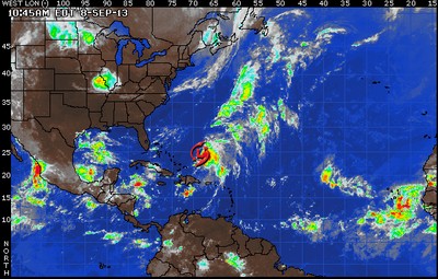
Southwesterly wind shear over the depression is helping to displace some of the storms to the north and east; however, environmental conditions should be just favorable enough for some additional strengthening of this depression on Sunday. Thus, Tropical Depression 11 should become Tropical Storm Jerry sometime on Sunday afternoon or night.

As for the track, T.D. 11 will move slowly off to the east-northeast over the next day before ducking southward. Thereafter, the storm will briefly move toward the northwest, performing a loop, and ending up near its current position. By late week, T.D. 11 will be swept off to the north and east by a trough that is currently over the Midwest.

A second area of interest is a cluster of showers and thunderstorms situated across the central Caribbean. These showers and thunderstorms are gradually expected to become better organized next week as they drift northwestward into and through the northern Caribbean.


An enhanced threat for heavier showers and thunderstorms are likely across central and western Cuba next week as deeper tropical moisture moves across the country. By the end of next week, the feature of interest will likely migrate into the warm waters of the central or eastern Gulf of Mexico where further development into an organized tropical system is possible. This feature will have to be watched closely.


Mittwoch, 18. September 2013

Watching the Gulf Again; Humberto Over Open Waters


Tropical Storm Humberto remains around 1,000 miles to the west-southwest of the Azores. Satellite imagery continues to show a fairly disorganized system with most of the thunderstorms to the east of the low-level center of circulation. This system will have a window over the next 24 hours or so to strengthen somewhat as shear lessens and it remains over ocean waters that are just warm enough to support tropical development as it moves off to the north.

Eventually, Humberto will be picked up by a cold front approaching from the west and very quickly accelerate off to the northeast by Friday and Friday night into cooler waters and it will transition to a non-tropical low pressure center by Saturday morning. We do not expect Humberto to impact any land masses over the next five days as it will remain well northwest of the Azores, making its closest pass to the islands Friday evening.

Aside from Humberto, we are watching an area of surface low pressure that is currently moving across the southern Yucatan Peninsula that is producing a large and disorganized swath of drenching showers and thunderstorms. An Air Force Hurricane Hunter Aircraft is scheduled to investigate this system later today if it becomes necessary to gather more information and data on it. This area of disturbed weather will move into the Bay of Campeche later today and then continue to slowly drift westward across the bay and into the southern Gulf of Mexico a few hundred miles to the southeast of Brownsville, Texas by Friday.


The low will be in an environment of low shear and warm waters, so we do expect it to become a tropical depression or even tropical storm over the next day or so. This system will then stall in the Gulf on Friday as an upper level system and cold front move into east and south Texas. If the upper level system extends far enough to the south it should draw this system north then northeast Friday night and Saturday. If this happens the system could move into the northern Gulf coast later Saturday or Saturday night as a tropical storm.

Another possible scenario is for the upper level system to bypass this developing tropical system. If this were to happen the system would be left to drift east then northeast slowly and then move towards Florida next week. Since there is a lot of uncertainty in the development and movement of this low pressure area we are urging all interests in and around the Gulf of Mexico to monitor the progress of this feature.

Elsewhere across the basin, no tropical development is expected in the next 24 to 48 hours.

Dienstag, 17. September 2013

Tropical Storm Ingrid Hit Mexico

The remnants of Hurricane Ingrid and Tropical Storm Manuel drenched Mexico's Gulf and Pacific coasts with more torrential rains Monday, flooding towns and cities, cutting highways and setting off landslides in a national emergency that federal authorities said had caused at least 34 deaths.
The Mexican government said the country had not seen a similar weather crisis since 1958, when the country was simultaneously hit by two tropical storms on different coasts.


 The governor of the Gulf Coast state of Veracruz announced that 12 people died when a landslide smashed into a bus traveling through the town of Altotonga, about 40 miles northwest of the state capital. Gov. Javier Duarte said the death toll could grow as bodies were recovered.


More than 23,000 people fled their homes in the state due to heavy rains spawned by what had been Hurricane Ingrid, and 9,000 went to emergency shelters. At least 20 highways and 12 bridges had been damaged, the state's civil protection authority said.


Some of the heaviest damage was in the southern coastal state of Guerrero, where Mexico's government reported 15 confirmed deaths from Manuel. State officials said people had been killed in landslides, drownings in a swollen river and a truck crash on a rain-slickened mountain highway.


Flooding closed the main highway from Mexico City to Acapulco, and power cuts shut the resort city's main airport, isolating many tourists over a long holiday weekend. Telephone service was cut around the state, though authorities said it was mostly restored by Monday afternoon.


Mexico's federal Civil Protection coordinator, Luis Felipe Puente, told reporters late Sunday that stormy weather from one or both of the two systems also caused three deaths in Hidalgo, three in Puebla and one in Oaxaca.


Manuel came ashore as a tropical storm Sunday afternoon near the Pacific port of Manzanillo, but quickly lost strength and was downgraded to a tropical depression late Sunday. It dissipated into an unorganized rain system Monday.
Manuel dumped heavy rains over much of the states of Guerrero, Michoacan, Colima, Jalisco and Nayarit, presenting a dangerous threat in mountains where flash floods and mudslides were possible.


Ingrid had maximum sustained winds of 35 mph late Monday afternoon and was centered about 75 miles west of the coastal town of La Pesca in Tamaulipas. It was moving west at 6 mph. It was expected to dump 10-15 inches of rain over much of eastern Mexico, with maximums of 25 inches in some isolated areas.


Montag, 16. September 2013

Disaster Imminent as Ingrid is About to Make Landfall in Mexico


Ingrid is a minimal Category 1 hurricane centered in the southwestern Gulf of Mexico. Ingrid should maintain strength as it makes landfall to the north of Tampico, Mexico, later this morning into the early afternoon hours. Heavy rainbands are already impacting northeastern Mexico, but conditions will continue to deteriorate through Sunday night.


Torrential rain, damaging winds and coastal flooding will occur between Tampico, Mexico and the U.S. border until Ingrid moves inland later today. Wind gusts to 100 mph and coastal water inundation of 3 to 6 feet along the immediate coast should be anticipated near and just north of landfall.


Inland fresh water flooding and mudslides will be life threatening. Widespread rainfall totals of 8-16 inches with locally 30 inches in the mountains of northeastern Mexico are forecast. In the United States, Ingrid will bring a coastal water inundation of 1-3 feet along the barrier islands of South Texas today. However, the rainfall will be largely beneficial across South Texas as rounds of showers and thunderstorms move across the region.


Sonntag, 15. September 2013

Ingrid Continues to Move Towards Mexico


Warm water is providing plenty of fuel to Ingrid in the southern Gulf of Mexico and the second hurricane of the season in the Atlantic Basin continues to become a little stronger with sustained winds of 85 mph.

The center of Ingrid is about 150 miles east of Tampico, Mexico. The worst of Ingrid will largely remain away from land on today, but downpours and rough seas will increase throughout the day in northeast Mexico and South Texas. However, torrential rain and damaging winds will begin to target northern Veracruz and southern Tamaulipas tonight as Ingrid begins to approach east-central Mexico as a Category 1 hurricane.

 Peak wind gusts up to 105 mph, torrential rainfall, and coastal flooding will threaten areas surrounding the landfall area early Monday morning. A landfall near or just north of Tampico, Mexico is expected late tonight or early Monday morning. Life-threatening flash flooding and mudslides will occur across east-central Mexico between Monday and Wednesday as rainfall totals exceed one foot in many areas. In the mountainous areas 20-30 inches of rain is likely with severe flooding and mudslides. Locally heavy rainfall will extend north into southern Texas early next week as well, but this may be largely beneficial to their current drought.


Meanwhile, Humberto remains a tropical rainstorm in the east-central Atlantic. However, Humberto will move into noticeably warmer water once again early next week and has a good chance at regaining tropical characteristics. In fact, it could become a hurricane by the middle of next week. Either way, no impact to land is expected as it crosses into the central Atlantic Ocean through early next week.

Elsewhere, there are no imminent threats for tropical development across the remainder of the basin.

Freitag, 13. September 2013

Ingrid forms in the Bay of Campeche


Over the next 24 hours, the system will only drift to the west and northwest. The system will then begin to move a bit faster Saturday evening into Sunday off to the northwest, and we are expecting landfall Sunday evening along the Mexican coast just to the north of Tampico.

At the time of landfall, the system should be a strong tropical storm and perhaps even near hurricane status. Beyond landfall, the system will weaken quickly on Monday and Tuesday as it moves into the interior of Mexico but will continue to bring torrential rainfall through at least next Tuesday across parts of Mexico and South Texas.


The main impacts from Tropical Storm Ingrid will be the heavy, flooding rainfall across much of southern and eastern Mexico over the next several days. Deep tropical moisture from this system and Tropical Depression 13 off the southwest coast of Mexico will be forced up into the Sierra Madre Oriental mountains will bring rainfall totals of 6-12 inches with the potential for localized totals of over 20 inches in the mountains. This torrential rainfall will lead to severe life-threatening flooding and mudslides over much of eastern Mexico through this weekend and into early next week. Some of the rich tropical moisture from this system will reach deep South Texas bringing rainfall totals of 2-4 inches this weekend into early next week.

Mittwoch, 11. September 2013

Number One!

Humberto Becomes Season's First Hurricane; Gabrielle Spinning Away From Bermuda.


Gabrielle is currently to the west-northwest of Bermuda this morning and is producing heavy rain and gusty winds for the area. Rainfall amounts of 2-4 inches can be expected by the end of this morning. Sustained winds of around 40 mph with gusts as high as 60 mph are expected through the rest of the morning. The combination of heavy rain and strong winds can bring scattered power outages and perhaps some damage to weaker structures. Increasing rain and wind are expected over eastern Nova Scotia Friday and Friday night as Gabrielle passes near or just off to the east of Nova Scotia. Gabrielle will make a transition from a tropical to a post-tropical storm later Friday or Friday night, and then impact Newfoundland with some rain and wind later Friday into Saturday. Beyond Saturday, what is left of Gabrielle will race across the northern Atlantic Ocean.

Humberto has become the first Hurricane of the season in the Atlantic Ocean this morning. Humberto will take a more northerly turn later today and Thursday as the storm interacts with a disturbance situated to the southwest. A semi-permanent high pressure system near the Azores will deflect Humberto back to a more westerly direction as for the end of the week and through the weekend. Humberto poses no threat to land for the rest of the week and through this weekend.


Disorganized showers and thunderstorms over the western Caribbean are associated with a tropical wave that is about to push westward into the Yucatan Peninsula. This wave will bring an enhanced threat for showers and storms to the Yucatan through Thursday. On Thursday, this tropical wave will start to emerge westward into the southern Gulf of Mexico. Environmental conditions and some model guidance suggest that this wave will have the opportunity to acquire tropical characteristics over the southern Gulf of Mexico by the end of the week into this weekend. Regardless of tropical development, an enhanced threat for heavier showers and thunderstorms is possible across northeastern Mexico and southern Texas later this weekend.


Dienstag, 10. September 2013

Humberto Nearly a Hurricane; Gabrielle Has Regenerated Into a Tropical Storm


Humberto is currently 150 miles west of the southernmost Cape Verde Islands. Total rainfall of 3-6 inches is expected through Wednesday across the Cape Verde Islands which can cause flooding and mudslides. Environmental conditions will be mostly favorable for Humberto to continue to gain strength through the latter part of the workweek, and the storm is expected to acquire hurricane status on Wednesday or maybe even later today.

Gabrielle has regenerated into a tropical storm this morning. Gabrielle is located about 185 miles south of Bermuda. The system is expected to affect Bermuda with gusty winds up to tropical storm force and heavy rainfall. Rainfall amounts of 2-4 inches are expected with as much as 6 inches locally. The worst of the impacts will be felt tonight and tomorrow across the island. The system will move away from Bermuda later in the week and potentially move into Atlantic Canada by this upcoming weekend.


A weak tropical wave currently over the western Caribbean will drift westward through the Yucatan Peninsula during the middle of this week and emerge into the southern Gulf of Mexico for the latter and end of the week. Some guidance suggests that there is a chance this disturbance will acquire tropical characteristics once it move into the southern Gulf of Mexico later this week.

Regardless of development, an enhanced threat for heavier showers and storms will exist across the Yucatan Peninsula through the middle of the week. This will be an area that will have to be monitored.


Montag, 9. September 2013

Humberto Passing South of Cape Verde Islands


Tropical Storm Humberto is located at 13.6 N, -24.8 W with maximum sustained winds of 45 mph, gusting to 60 mph


Tropical Storm Humberto is gradually gaining strength south of the Cape Verde Islands today as it tracks westward. It is in a favorable environment for further development over the next 24 to 48 hours. Through Tuesday, Humberto will take a more west-northwestward track which will carry the storm's center a short distance south and then southwest of the Cape Verde Islands.

Humberto will bring some wind and rain to the Cape Verde Islands, the severity of which will depend upon how quickly the storm strengthens. The potential exists for damaging winds to develop as the storm strengthens further while passing nearby to the south. Therefore, a tropical storm warning is in effect for the southern Cape Verde Islands of Maio, Santiago, Fogo and Brava.

After that, all computer guidance shows this system heading northwestward into the dry and stable air over the middle of the Atlantic in the coming days. That combined with increasing shear should cause it to weaken. That being said, it has a chance to become the seasons first hurricane by Tuesday before it reaches the unfavorable environment. Once clear of the Cape Verde Islands, it will be several days before it affects another land mass, if it ever does have any impact on land again.


The next feature of interest is the tropical wave along 40 west, south of 25 north, over the middle of the tropical Atlantic. There is a turning in the clouds with this wave, but it is embedded in a generally dry air mass and it is sheared somewhat as well with the upper winds south-southwesterly, so despite the decent amount of thunderstorm activity associated with this system, further development is unlikely.

Of greater concern are the remnants of Gabrielle currently west-southwest of Bermuda. This feature is looking somewhat better organized than yesterday although it remains sheared due to upper-level southerly winds. The upper winds likely become even more unfavorable starting on Monday. Either way, it will stay east of the United States and is only a concern for Bermuda at this point. It will bring some squally weather to that island on Monday night through Tuesday even if it does not return to life as a tropical cyclone.


Finally, there is a tropical wave over the northwestern Caribbean. There is no sign of further development here, either, but this feature will have to be watched next week once it reaches the Gulf of Mexico or Bay of Campeche and joins forces with a disorganized disturbance currently generating thunderstorms there.

Tropical Depression 9 Upgraded to Tropical Storm Humberto

We are currently tracking several features over the Atlantic basin, but only two of them are any sort of imminent threat.


Tropical Depression 9 has intensified into Tropical Storm Humberto early this morning southeast of the Cape Verde Islands. It is in a favorable environment for further development over the next 24 to 48 hours. Through Monday and Tuesday, a west-northwestward track will carry the storm's center a short distance south of the Cape Verde Islands.

Humberto will bring some wind and rain to the Cape Verde Islands, the severity of which will depend upon how quickly the depression strengthens. The potential exists for damaging winds to develop as the storm strengthens further while passing nearby to the south. Therefore, a tropical storm warning is in effect for the southern Cape Verde Islands of Maio, Santiago, Fogo and Brava.

After that, all computer guidance shows this system heading northwestward into the dry and stable air over the middle of the Atlantic in the coming days. That combined with increasing shear should cause it to weaken. That being said, it has a chance to become the seasons first hurricane by Tuesday before it reaches the unfavorable environment. Once clear of the Cape Verde Islands, it will be several days before it affects another land mass, if it ever does have any impact on land again.


The next feature of interest is the tropical wave along 40 west, south of 25 north, over the middle of the tropical Atlantic. There is a turning in the clouds with this wave, but it is embedded in a generally dry air mass and it is sheared somewhat as well with the upper winds south-southwesterly, so despite the decent amount of thunderstorm activity associated with this system, further development is unlikely.

Of greater concern are the remnants of Gabrielle currently west-southwest of Bermuda. This feature is looking somewhat better organized than yesterday although it remains sheared due to upper-level southerly winds. The upper winds likely become even more unfavorable starting on Monday. Either way, it will stay east of the United States and is only a concern for Bermuda at this point. It will bring some squally weather to that island on Monday night through Tuesday even if it does not return to life as a tropical cyclone.

Finally, there is a tropical wave over the northwestern Caribbean. There is no sign of further development here, either, but this feature will have to be watched next week once it reaches the Gulf of Mexico or Bay of Campeche and joins forces with a disorganized disturbance currently generating thunderstorms there.

Sonntag, 8. September 2013

Development Expected with Wave Near Africa

The next named tropical storm in the Atlantic Basin will be Humberto.


The next named tropical storm in the Atlantic Basin will be Humberto, and we could have that within the next 24 hours.


Shower and thunderstorm activity has increased in coverage and organization from a wave that recently emerged off the coast of Africa. This activity is gathering around an area of low pressure several hundred miles east-southeast of the southern Cape Verde Islands. Conditions appear favorable for additional development of this system and we could have a tropical depression or even tropical storm within the next 24 hours.

The low pressure area will be moving to the west-northwest over the next few days. Interests in the Cape Verde Islands should keep abreast of the potential for heavy rain and gusty winds by Monday.

Gabrielle, a tropical rainstorm, is a couple of hundred miles northeast of the southeastern Bahamas. The leftover low-level circulation remains broad and poorly defined. The system will continue to track to the north on Sunday and then track northward or northeastward early next week ahead of a cold front.

Westerly winds aloft should inhibit any development or organization through Sunday, but there may be a period of more conducive conditions for organization early next week. As it stands, even if there were to be a regeneration of Gabrielle, there is no threat to land.


Another area to watch in the coming days will continue to be down in the southwestern Gulf of Mexico and Bay of Campeche. Pressures are low, moisture is high and waters are warm, so it is not out of the question that any surface trough or mid- or upper-level feature gets some shower and thunderstorm activity going that will start the process of tropical development. Just something to keep an eye on for now as we head into and through the new week.

Freitag, 6. September 2013

Remnant of Gabrielle

Still Watching Southwest Gulf


Gabrielle has been downgraded to a tropical rainstorm now, but we will be watching the remnants tracking northwestward then northward over the next couple of days. There remains a broad counter clockwise rotation between Puerto Rico and Hispaniola, but the showers and thunderstorms are displaced well to the east, over and south of Puerto Rico and the U.S. Virgin Islands. Additional rainfall of 2-4 inches can be expected with the deep moisture. The former Gabrielle may merge with a large area of disturbed weather currently to the northeast of the Great Antilles. This merged system will move northward and there is a chance this might develop into an organized tropical system in a couple of days. Even if this happens, a weakening cold front should keep it well away from land.


Meanwhile, data from a reconnaissance aircraft on Thursday suggests the system in the southwest Gulf of Mexico does not have a coherent or common low level circulation center. Showers and thunderstorms which blossomed during the day Thursday diminished overnight. If convection can get going again today it could wrap up and develop the low pressure area into into a tropical depression or storm before moving inland over Mexico later today or tonight. Regardless of development the low will bring moderate to heavy rainfall over parts of the Mexican and southern Texas coast during the next few days.

Donnerstag, 5. September 2013

Tropical Storm Gabrielle

Tropical Storm Gabrielle Bringing Heavy Rain to Puerto Rico.


Gabrielle continues to slowly move off to the northwest early Thursday morning in the northeast Caribbean Sea, with its center less than 50 miles to the south of Ponce, Puerto Rico. This slow northwest movement will continue the rest of today through tonight and Friday, likely taking the center of the storm through the Mona Passage between Puerto Rico and the Dominican Republic.

The combination of land interaction, southwesterly wind shear and a tropical wave just to the northeast of Gabrielle should keep the system from strengthening significantly in the next 24 to 48 hours. Beyond that timeframe, the system will pull northward away from the Dominican Republic and should have an opportunity to strengthen somewhat. However, shear will continue to affect the storm through the weekend and we feel that will keep it from becoming anything more than a tropical storm.


By early next week, the movement of Gabrielle becomes more uncertain. We feel an upper-level trough moving off the East Coast of the United States will pick Gabrielle up in its flow and steer it northeastward, perhaps not all that far from Bermuda. However, the connection between Gabrielle and the trough could be missed, perhaps causing the storm to become nearly stationary or even drift westward towards the Southeast Coast of the United States. Regardless, over the next several days, any impact on the southeastern United States from Gabrielle should be limited to rough surf and higher waves.

Current satellite imagery shows a robust area of thunderstorms in association with Gabrielle that have really expanded in the last 4-6 hours. These thunderstorms are located mainly to the east of the low-level center and have been pounding the Virgin Islands and eastern half of Puerto Rico with heavy rainfall thus far early Thursday morning. Eventually, the heavy rain will shift westward later today into tonight to affect the western half of Puerto Rico and eventually eastern parts of the Dominican Republic as well.

In the course of the next 24 hours, a general 1-4 inches of additional rainfall can cause flash-flooding across Puerto Rico and eastern Hispaniola. Amounts in excess of 10 inches can fall across the mountainous interior of Puerto Rico, causing life-threatening flash flooding and mudslides. Wind gusts around 40 mph near the coast of Puerto Rico today may also cause sporadic power outages.


Aside from Gabrielle, we are monitoring several other areas across the Atlantic Basin for potential development. The first is a cluster of thunderstorms located to the northeast of Gabrielle northeast of the northern Leeward Islands. Due to the disorganization of this feature and its proximity to Gabrielle, any further development of this feature is unlikely. We are also watching another area of concern over the southwest Gulf of Mexico in the Bay of Campeche. With lower than normal surface pressures in this area combined with very warm waters, there is potential for further development with this feature through the weekend.

All interests in the southern Gulf of Mexico should closely monitor this area over the next few days and check back often with AccuWeather.com for further updates. Finally, a cluster of thunderstorms over western Africa associated with a tropical wave will emerge into the open waters of the far eastern Atlantic over the next couple of days. There is some potential for this wave to develop early next week as it moves away from the African coast.

Mittwoch, 4. September 2013

Two Tropical Waves to Watch

The Atlantic Basin remains void of any organized tropical systems. 


 However, we are focusing in on two areas that are producing disturbed weather that could evolve into organized tropical features.


A tropical wave over the eastern Caribbean and another tropical wave just east of the Lesser Antilles is generating a large area of disturbed weather that covers a large part of the eastern Caribbean. The main area of organized convection is to the south and east of Puerto Rico. This low and the large cyclonic flow around it will interact with the higher terrain of Hispaniola and Puerto Rico during the next two-three days which may inhibit development.


Nevertheless, recent satellite imagery has shown convection becoming better organized around a low center, and this system may become better organized today, possibly becoming a tropical depression or storm. There is an area of shear draped across the northern Caribbean and this system will have to interact with that through the rest of the week and into Saturday, which should inhibit further development. This shear should diminish on Saturday night and Sunday allowing the system to re-develop north of Hispaniola around Sunday and Monday of next week. Computer forecasts show support for development and take this system north, then northeast. This does not appear to be a path that would bring any direct impacts to the United States.


A large area of disturbed weather over the southern Gulf of Mexico and the Yucatan Peninsula is projected to slowly work westward. We don't see a defined low pressure area yet, but there is some cyclonic turning in the overall cloud motion with this system. Shear will limit development during the next 24 hours, then there is an opportunity for low pressure to become established over the southern Bay of Campeche on Thursday and Friday.

Dienstag, 3. September 2013

Monitoring Tropical Waves

Monitoring Tropical Waves: Lesser Antilles, Bay of Campeche; Shear, Dry Air Halt Eastern Atlantic Development.


There are plenty of tropical waves to monitor in the Atlantic Basin, but some will require more focus than others through the middle of this week.
A pair of tropical waves located near and just east of the Lesser Antilles continue to produce widespread downpours and thunderstorms in an area from the Lesser Antilles east to about 50 west.


A broad area of surface low pressure is also associated with this activity. While wind shear remains low across this area, there is a pocket of dry air just to the north, between 17 and 20 north. This dry air to the north is being circulated into these waves, helping to inhibit development at this time. The dry air is expected to wane through Wednesday as this area of disturbed weather moves west-northwest. The diminishing dry air could be enough to help spur some tropical development over the next couple of days somewhere between 75 and 60 west, south of 25 north. Regardless of development, locally heavy rainfall and gusty winds will impact areas from the Lesser Antilles to Hispaniola this week.

Farther west, a tropical wave moving into the Bay of Campeche will have to be monitored over the next couple of days. While the wave is producing a broad area of tropical downpours and thunderstorms across parts of Central America and southern Mexico, it is very disorganized. Wind shear may limit the potential for tropical development in the Bay of Campeche Wednesday into Thursday, but there will be plenty of warm water to help fuel a potential system. Either way, locally heavy rain will produce flash flooding and mudslide risks over parts of Central America and southern Mexico over the next few days.


Meanwhile, a tropical wave is coming off of the African coast in the far eastern Atlantic Ocean. There is a good amount of shower and thunderstorm activity associated with this wave, but it may have some difficulty becoming better organized with some wind shear and dry air in the region. Nonetheless, it will have to be monitored for development over the next few days.
Elsewhere, there are no signifiant threats for development across the remainder of the basin.

Montag, 2. September 2013

Tropical Waves Still Failing to Develop

In the tropical Atlantic


In the tropical Atlantic, there are currently a few tropical waves, however only one looks to have the potential to develop over the next 24 to 48 hours.
The most significant feature across the tropical Atlantic is a wave just east of the Lesser Antilles. Showers and thunderstorms associated with this system continue to remain somewhat organized, however no circulation center has managed to become pronounced and therefore, the system remains largely disorganized.


As the wave begins to take a westerly or even just south of west track, it will move into more favorable conditions and have a higher likelihood of developing over the open waters of the Caribbean. If a track farther north occurs, it will have to deal with more land interaction and higher wind shear which would likely result in just a large area of unsettled weather across the region.

Over the next couple of the days, this tropical wave will bring showers and locally gusty winds to the Lesser Antilles. Showers and thunderstorms will then advance with the wave into the northeastern Caribbean Sea, affecting the Virgin Islands and Puerto Rico by Tuesday and perhaps Wednesday. The worst weather may remain farther south over the open Caribbean during this time.


Another tropical wave is currently located near the Yucatan Peninsula and far western Cuba. While the system has significant convection associated with it, land interaction and wind shear will keep the wave from organizing.

A new wave is moving off the coast of Africa as well, however dry air from the north, along with the fact that it's still partially over Africa, will prevent this wave from developing in the short term.

Sonntag, 1. September 2013

Tropical Waves, but No Cyclones in the Atlantic

The Atlantic Basin remains quiet today 


with no organized tropical systems. There are a few tropical waves to watch, but the chance of any of the the waves to develop into an organized tropical cyclone over the next couple of days remains small.

A tropical wave off the west coast of Africa will track westward and bring some showers and gusty winds to the Cape Verde Islands today. This wave is being suppressed by dry air, and development of any organized convection will be inhibited by this unfavorable environment.


We are also monitoring a tropical wave with an associated weak area of low pressure near the Lesser Antilles. There are some showers and thunderstorms associated with this tropical wave and low pressure area, but there is not any well defined surface wind circulation. Further tropical development is not anticipated in the near term as there appears to be too much contrasting flow through the atmosphere. As the disturbance tracks off to the west over the next couple of days, it will bring showers and locally gusty winds to the Lesser Antilles.


Showers and thunderstorms will then advance with the wave into the northeastern Caribbean Sea, affecting the Virgin Islands and Puerto Rico next week when atmospheric conditions may become a little more favorable for development.

Another tropical wave in the western Caribbean is moving westward and will not develop.